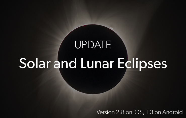
Update PhotoPills Now and Start Planning your Sun and Moon Eclipse Photo ideas!
Note: Tap here to learn how to update PhotoPills on iOS & Android.
Finally!
We’ve added the best upcoming Sun and Moon Eclipses to the PhotoPills Planner.
Including:
- The next July 27th 2018 Total Moon eclipse.
- And the epic July 2nd 2019 Total Solar eclipse.
And many more!
So, update PhotoPills now to enjoy the following improvements...
Panel 9: Eclipse selector button and main eclipse info
There are two eclipse panels above the map. Swipe the panels to the left till you get to panel Panel 9 and Panel 10.
Choose the eclipse
Tap the button you see on Panel 9 to choose the Sun or Moon eclipse you wish to plan form a Calendar. Once selected, the eclipse information will appear on Panel 9, on Panel 10 and on the Map.
Note: As I’ll explain you further down, you can also switch on the Eclipse Map layer by using the Map settings button. You’ll find it on the Map on the bottom right-hand corner (next to the (+) Map button).
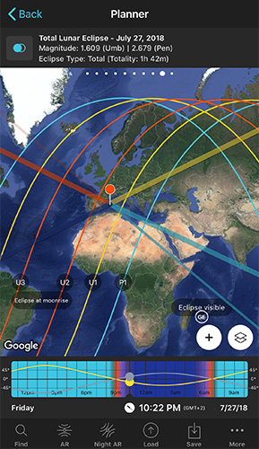
Eclipse information
On Panel 9 you’ll also find the eclipse name, date, magnitude and type (partial, total).
- Eclipse Magnitude: For a solar eclipse, it represents how much of the solar diameter is covered by the Moon. It usually has a value between 0 and 1 inclusive, where 1 is totally eclipsed. For a lunar eclipse, it represents how much of the Moon diameter is covered by Earth's shadow. Because Earth casts two different shadows (umbral and penumbral), PhotoPills gives you two magnitudes, the umbral magnitude (umb) and the umbral magnitude (pen).
- Eclipse Type: The eclipse type that can be seen from the red pin position (total, partial or not visible).
Panel 10: Eclipse phase picture and times
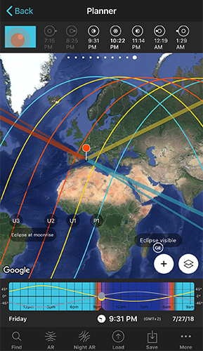
Panel 10 displays the following eclipse information:
Eclipse phase picture
The picture you see on panel 10 shows the eclipse phase for the selected time and Red Pin position. Tap it to set time to the next important eclipse phase.
Eclipse phase times
On the Panel, you also have the time of all the key eclipse phases. Tap and hold on the desired eclipse phase time to set it on the Time bar.
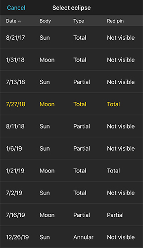
Map Settings Button: Eclipse Layer and Eclipse Calendar
To switch on the Eclipse map information layer, you can also tap the Map Settings Button (next to the + Map button). And then tap on the Eye icon next to the new Eclipse layer.
From the Map Settings screen, tap on the Eclipse layer to see the calendar. Choose the eclipse you wish to plan and finally tap on Done (top right hand corner of the Map Settings screen).
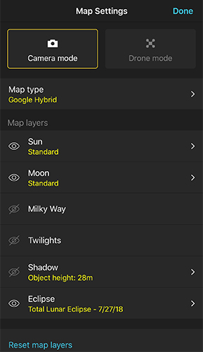
When you choose an eclipse from the calendar, the key information will be displayed on the Map, on Panel 9 and on Panel 10.
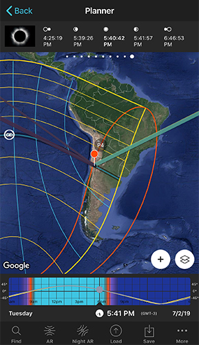
This is the Sun Eclipse information you'll find on the Map:
- Map central dark area: It’s the path of totality (the area of total darkness). In other words, the area where you can observe how the Moon will completely cover the Sun.
- Map blue line within the path of totality: It’s the centerline. The further away from the centerline you are (while being in the path), the shorter amount of time the Sun will be covered by the Moon. In other words, you will see a shorter totality duration.
- Map yellow lines: Outside the path of totality you’ll be able to see a partial eclipse. The first yellow line on both sides of the path represents the locations where the Moon will cover 80% of the Sun. The next yellow line represents 60% and so on. The furthest from the path of totality, the more partial the eclipse will be.
- Map Greatest Duration Point (GD): The location where totality lasts longer, where the phase of total eclipse lasts longer.
- Map Greatest Eclipse Point (GE): Don’t confuse it with the Greatest Duration Point. The Greatest Eclipse Point is not where the total eclipse lasts longer. It is just a geometric point. GE wasn’t a good name choice at all. It is actually the location where the shadow of the Moon is nearest to the center of the Earth. Sometimes, it falls very close to the GD point, but it’s not always the case.
Regarding the Moon eclipses, you'll need first to understand the 7 phases of a total lunar eclipse:
- Penumbral eclipse begins (P1): When the penumbral part of Earth's shadow starts moving over the Moon.
- Partial eclipse begins (U1): Earth's umbra starts covering the Moon.
- Total eclipse begins (U2): Earth's umbra completely covers the Moon. The Moon turns into red, brown or yellow.
- Greatest eclipse: When the Moon passes closest to the center of the Earth's shadow.
- Total eclipse ends (U3): Earth's umbra starts moving away from the Moon.
- Partial eclipse ends (U4): Earth's umbra completely leaves the Moon.
- Penumbral eclipse ends (P4): Earth's penumbral shadow moves away from the Moon. It's the end of the eclipse.
Given the Moon eclipse phases, this is the Moon Eclipse information you'll find on the Map:
- Eclipse visible area: The Map label Eclipse visible shows you the map area where all phases of the Moon eclipse are visible (P1, U1, U2, Total, U3, U4, P4). This is the area between the blue lines (P1 and P4).
- Eclipse visible at Moonrise area: The Map label Eclipse visible at Moonrise shows you the map area where at least one of the eclipse phases is visible during Moonrise. This is the area between the two blue lines (P4 and P1) which also contains the yellow and red lines.
- Eclipse visible at Moonset area: The Map label Eclipse visible at Moonset shows you the map area where at least one of the eclipse phases is visible during Moonset. This is the area between the two blue lines (P4 and P1) which also contains the yellow and red lines.
- Eclipse not visible area: The Map label Eclipse not visible shows you the map area where the eclipse is not visible (because the eclipse happens when the Moon is under the horizon). This is the area between the blue lines (P1 and P4).
- Map Greatest Eclipse Point (GE): It's the moment when the Moon passes closest to the axis of Earth's shadow.
For the eclipse Moonrise area:
- Area between the blue and yellow lines (P4 and U4): It represents the locations where only the Penumbral eclipse and the Penumbral eclipse ends (P4) are visible.
- Area between the yellow and red lines (U4 and U3): It represents the locations where only the Partial eclipse, Partial eclipse ends (U4) and the Penumbral eclipse ends (P4) are visible.
- Area between the two red lines (U3 and U2): It represents the locations where all the Moon eclipse phases are visible but the Penumbral eclipse begins (P1), the Partial eclipse begins (U1) and the Total eclipse begins (U2).
- Area between the red and yellow lines (U2 and U1): It represents the locations where all the Moon eclipse phases are visible but the Penumbral eclipse begins (P1) and the Partial eclipse begins (U1).
- Area between the yellow and blue lines (U1 and P1): It represents the locations where all the Moon eclipse phases are visible but the Penumbral eclipse begins (P1).
For the eclipse Moonset area:
- Area between the blue and yellow lines (P4 and U4): It represents the locations where all the Moon eclipse phases are visible but the Penumbral eclipse ends (P4).
- Area between the yellow and red lines (U4 and U3): It represents the locations where all the Moon eclipse phases are visible but the Penumbral eclipse ends (P4) and the Partial eclipse ends (U4).
- Area between the two red lines (U3 and U2): It represents the locations where all the Moon eclipse phases are visible but the Penumbral eclipse ends (P4), the Partial eclipse ends (U4) and the Total eclipse ends (U3).
- Area between the red and yellow lines (U2 and U1): It represents the locations where only the Partial eclipse, Partial eclipse begins (U1) and the Penumbral eclipse begins (P1) are visible.
- Area between the yellow and blue lines (U1 and P1): It represents the locations where only the Penumbral eclipse and the Penumbral eclipse begins (P1) are visible.
Wish to learn how to plan an eclipse?
Watch the following video tutorial: How to plan the August 21st 2017 total solar eclipse.
Other improvements…
- New cameras added: Xiaomi Mi Drone (4K version), Mi Drone (1080P version); Panasonic Lumix DC-TS7 (DC-FT7); Fujifilm X-T100
- Bug fixes.
Please, if you find a bug (or have a suggestion), send us an email to [email protected] and we'll fix it as soon as possible. :)
We hope you enjoy this update.
Let us know how it goes!
We’ll keep improving.
Imagine. Plan. Shoot.!
Note: Tap here to learn how to update PhotoPills on iOS & Android.